

- Park opens every day of the year, including holidays, except for Wednesdays. The day use/entrance fee is $5.00 per vehicle.
- Park occasionally closes, completely or partially, to public riding for special event competitions, visit the park's Event Calendar.
- Check social media and/or call before you haul, (916) 985-7378. For general inquiries, email Prairie.City@parks.ca.gov.
Permits are required at Prairie City SVRA for any special events which require exclusive use of a facility in the park and defined as an activity beyond the usual scope of the state park system. This includes commercial photography. To obtain a Special Event permit you need to apply 30 days prior to the desired date. For additional information, please call (916) 985-5642 or email PCEvents@parks.ca.gov.
Welcome to Prairie City State Vehicular Recreation Area!


Prairie City Info Sheet (English)
Prairie City Info Sheet (Spanish)
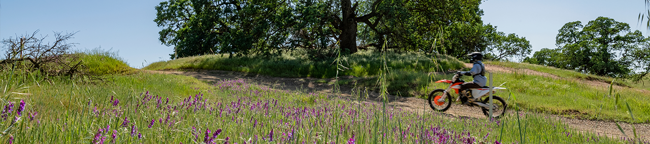
Visiting the Park The park is in eastern Sacramento County, 20 miles east of downtown Sacramento and 3 miles south of US Highway 50. It comprises approximately 1,344 acres of state lands, of which approximately 836 acres are currently devoted to off-highway vehicle (OHV) recreation. Prairie City SVRA is a showcase for OHV recreation and frequented by the local community. The park offers OHV enthusiasts a variety of interesting terrains and trails. Park elevations range from 240 to 350 feet above sea level. OHV recreational opportunities include trails and tracks for motorcycles, all-terrain vehicles (ATVs), four-wheel drive vehicles (4x4 vehicles), recreational OHVs (ROV/SXS/UTV), karts, and quarter midget vehicles.
The park is one of the most specialized units in the California State Park System and is host to many major OHV events. The busiest months at Prairie City SVRA occur October through June. Major competition events include the annual Hangtown Motocross Classic, Prairie City Grand Prix, Lilliputian Hare Scramble, Road to Mammoth Qualifier, and NorCal Rock Racing Ultra4 Stampede. State Park events include the annual Visitor Appreciation Day in October and Headlight Festival in December. Although Prairie City SVRA is mainly used for OHV recreation, it provides mountain bikers opportunities to use the park during a ten-race spring series on days when it is closed to OHV activity.
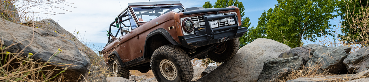
Park Facilities multiple restrooms, day-use sites for picnicking and staging, and recreational facilities that include loading ramps, OHV trails, the Prairie City SVRA Pro-Am MX Track, a motocross practice track, ATV practice track, 70cc beginner kids track (“mini track”) and 110cc kids track, 230cc intermediate motocross track, quarter midget track, go-kart track, 4x4 and obstacle area, and the Environmental Training Center.
- MX Practice Track is fully groomed each Wednesday (weather and staff permitting), and lightly groomed on Saturdays with watering as needed throughout the week. The track may be temporarily closed at times, until grooming can be performed.
 Park Terrain and Wildlife At the westernmost edge of the Sierra Nevada foothills, the Prairie City SVRA landscape consists of terrain that varies from flat, open grasslands to areas containing vernal pools, to rolling hills covered with native blue oaks, which provide habitat for a variety of plant and wildlife species. Much of the western portion of the SVRA includes piles of rock cobbles or dredge tailings, consisting of low mounds (5−10 feet high) of cobbles, silt, and sand, deposited during hydraulic and dredge gold mining operations. In the northern section of the park, there is a reclaimed gravel quarry (“The Pit”) that is generally bowl-shaped. The area containing dredge tailings is characterized by grassland and scattered cottonwood trees. The eastern portion of the SVRA is characterized by rolling hills and a vegetative cover of grassland and oak woodland. Visitors may see a wide range of birds and other wildlife reside in the area.
 The open grasslands attract golden eagles, red-tailed hawks, kestrels, and an occasional prairie falcon. Oak trees and brushy areas provide shelter for rabbits, quail, wild turkeys, and pheasants. Lewis' woodpeckers, acorn woodpeckers, and northern flickers can often be seen on the blue oaks. Deer are often seen in the morning or evening hours when they come out to graze, and coyotes are also seen occasionally.
Park History The SVRA includes ancestral lands of the Valley Nisenan Maidu Native Americans. Prairie City SVRA takes its name from the gold rush community that was located just northeast of the present-day park. During the Gold Rush era and until the 1950s, the area was the site of placer mining operations; it was owned first by the Natoma Water and Mining Company and later by the Capital Dredging Company. Today, reminders of that 1850s community include mine tailings and a historical marker, California Historical Landmark #464, which is located at the intersection of Prairie City Road and US 50. After the gold mining days, the area became home to a number of cattle ranches. In the early 1960s, Aerojet purchased the southern portion of the existing SVRA to build and test rocket engines for the US Government. In 1972, Aerojet sold 435 acres of its Sacramento property to Roy and Mary McGill, who established a cycle park. Sacramento County purchased the park in 1975, using funds from the Off-Highway Motor Vehicle Recreation (OHMVR) Cooperative Grants and Agreements program, and purchased an additional 401 acres in 1976. In 1988, the 836-acre park came under the ownership of the OHMVR Division.
Park Programming Prairie City SVRA provides opportunities for interpretation and educational programs related to regional and local natural resources, cultural history, and OHV recreation, by hosting a series of special events for visitors and outreach booths at competition events. Check social media pages and event calendar for upcoming events, programs, tours and more.
PCIG Public Quarterly Meetings
Environmental Training Center (ETC)
July Meeting Summary
Next Meeting- October 13, 2026 - 6 p.m. to 7 p.m. Join Online Here 
Quarterly meetings provide the public with information on current staffing, project developments, OHV regulations and safety. Meetings occur in person with on-line option when available. Park users and other stakeholders are encouraged to attend, as time is allotted at the end for public comment. For more information, email prairie.city@parks.ca.gov or phone (916) 985-1093.
Recreational Land Management
Providing long-term sustained OHV recreation opportunity is a top priority in SVRA Management. Provisions in California law require actions to stabilize soils and to provide for healthy wildlife populations in OHV recreation areas. Sites exist throughout the SVRA which have become eroded. There are projects ongoing to stabilize eroded areas by reshaping slopes, and by reseeding and replanting bare areas. Vegetation creates wildlife habitat while plant roots help stabilize the soil. Project areas are temporarily closed to OHV use through the use of barriers, such as fences, hay bales, brush piles and signing. Where possible, well designed OHV trails are immediately provided through project areas. Other project areas may be closed for a number of years before being again opened for OHV use. Your understanding and support in staying out of areas closed for restoration help ensure OHV recreation opportunities for years to come.

Spring 2026 - RTMP UNDERWAY!
The Road & Trail Management Plan (RTMP) implementation phase has begun. Riders will notice several areas of the park either being developed or under restoration. These projects reflect public input provided over the past several years of the plan's development.
RTMP Summary of Recommendations Map
We thank you for your initial input and look forward to more in the final trail/route phases of these projects. RTMP progress will be posted on social media, our main website and at the quarterly Prairie City Improvement Group (PCIG) Meetings.
Together, we're steering the future-improving connections, building trails, protecting the ride and expanding access!
Current and upcoming projects include:
(Zone 4, new area for development in former gravel pit next to Obstacle Course.)
Take the MX/ATV Trail System Survey
(Zone 3, area behind Pro-Am Track/Spectator Hill)
Project Update
Coyote Gulch Trail System Development
The 40-acre Coyote Gulch Initial Erosion Control Project aims to restore and protect the Coyote Gulch area within Zone 3 of Prairie City State Vehicular Recreation Area (SVRA). The main goal is to improve the health of the stream and surrounding landscape by reshaping the stream channel, repairing and reducing erosion damage, and restoring native vegetation. The project will also provide opportunities for new sustainable trail additions once the restoration is complete.
Once the restoration portion of the project is complete, opportunities for the public to participate in sustainable trail design. The RTMP recommends opening the Coyote Gulch area to motorcycles, including trials, and ATVs.

Project Phases
- Stream Restoration
The seasonal stream within the Coyote Gulch area will be reshaped and restored to a more natural form. This will help slow down water flow, reduce erosion, and improve overall stream function. Once the stream has been restored, fencing will be installed along the stream corridor to protect it.
- Road and Trail Crossings
New culverts will be installed where roads and trails cross the stream to allow water to flow more naturally and prevent damage from vehicle use.
- Trail and Soil Restoration
 Damaged trails and deeply eroded soils near the stream and within the project area will be graded and reshaped to restore natural conditions. These areas will be replanted with native plants to stabilize the soil and improve habitat. Additional measures like erosion control fabric and straw will be used to help plants establish and prevent runoff.
Closures
The Coyote Gulch area in Zone 3 is closed to public use during construction, and now includes "Spectator Hill" above the Pro-Am MX Track.
Project Timeline
The project began in April of 2026 and has an estimated completion date the summer of 2028.
(Zone 3, next to ATV Practice Track & Main Staging Area.)
(New area for development on the west side of main entrance road after the kiosk.)
Safe and Responsible OHV Operation
- Training Schedule (List of Classes for all OHVs)
- ATV Safety Training
- Dirt Bike Training
- ROV Safety Training
- Prairie City SVRA
- Carnegie SVRA
- Hollister Hills SVRA
- Hungry Valley SVRA
- Clay Pit SVRA
- Ocotillo Wells SVRA
- Heber Dunes SVRA
Park Concessions
- All Star Karting LLC (Go-Kart Race Track) PC Karting
- Armstrong Racing, LLC (Pro-Am MX Race Track) Rep Racing MX
- CA Adventours, LLC (ATV Tours) TV Tours